Glacier Bay Explorer
All Photos
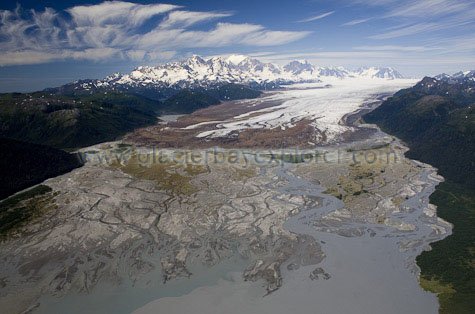
This is Taylor Bay and the Brady Icefield just 18 miles west of present day Glacier Bay. This scene is sometimes cited as similar to what Glacier 'Bay' may have looked like 1,000 years ago – that is, a lot of glacier, a big outwash plain and not so much 'bay'. If we use this modern day photo as an analog of the past, then present day cruise ship transfers of park rangers would occur in about the middle of the outwash plain and Bartlett Cove park facilities would be located along the green strip of land to the right.
The Brady Icefield shown in the photo has a flattish looking, gently sloping surface. But the under-ice land it is resting on is well below sea-level and is quite irregular in shape, just like the bottom of Glacier Bay. Use your imagination to project the sides of the mountains downward, beneath the ice. If you could lift all of the ice in this photo up in to the air it would leave behind a deep U-shaped valley. Two different scenarios are possible in this future ice-less time. The valley could fill with ocean water, just like Glacier Bay. More likely, however, there would be a great glacial lake, dammed up at its mouth by the outwash fan in Taylor Bay. Someday we may have a map of the land that is under all that ice. Until then, it is up to your imagination...